|
Trinity County Project News
In this issue:
2/3/14: Summit Creek Project
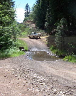 A partnership between 5C & Trinity County Department of Transportation to improve water quality in Summit Creek, a tributary of Carr Creek, Hayfork Creek and South Fork Trinity River. The projects goal was to reduce sediment into the stream, improve year round access for residents, and increase public safety for those crossing the stream during high flows. A partnership between 5C & Trinity County Department of Transportation to improve water quality in Summit Creek, a tributary of Carr Creek, Hayfork Creek and South Fork Trinity River. The projects goal was to reduce sediment into the stream, improve year round access for residents, and increase public safety for those crossing the stream during high flows.
By providing a culvert sized to handle the anticipated 100-year flows, vehicles will no longer discharge pollutants, compact the streambed and potentially crush aquatic species. Embedding the culvert in material designed to simulate the streambed prevents scour, provide habitat within the culvert for young steelhead trout and provide safe passage for all life stages of salmonids that may be present.
The majority of the Upper Carr Creek subwatershed was severely burned in 1964 during the Summit Fire which burned approximately 19,000 acres in the Middle Hayfork Watershed. There is evidence that Summit Creek is still recovering from this event due to the lack of substantial pool habitat and the amount of fine sediment present in the system. Current channel conditions have been affected in the last century primarily by mining activities within riparian areas, wildfires and subsequent salvage logging, grazing and timber management activities.
Summit Creek has traditionally been noted for supporting populations of steelhead trout and resident rainbow trout. Trout presence in Summit Creek was documented during a 1997 stream inventory (James 1997). A single trout was observed immediately upstream of the crossing during a 5C site visit June 5, 2012. Surveys of Carr Creek (Summit Creek is a tributary to Carr Creek) have found resident rainbow and steelhead trout and speckled dace.
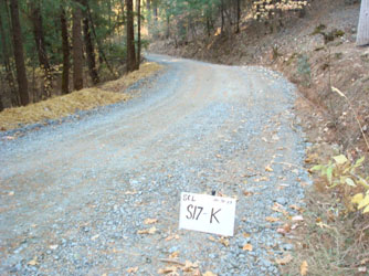
1/23/14: Browns Creek/Shady Lane Sediment Reduction Project underway
Shady Creek Lane was identified as the first target treatment road in this watershed because it contains the highest priority sediment sources identified in the road inventory. Landowners on this stretch of private road were active participants in the planning of the project, some providing in-kind services such as equipment, brushing labor or sharing of water supplies.
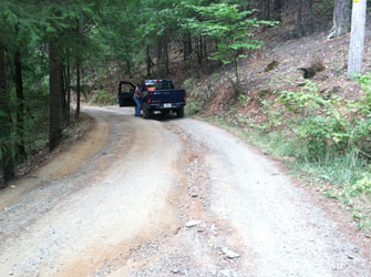 
The road suffered previous damage from storms & vehicles stuck in mud causing road drainage to run down the middle of the road--this caused deep rutting of the road and large amounts of sediment to enter the creek. Road treatments, including regrading of the road with an outslope, installation of ditch relief culverts and a rolling dip, will reduce sediment load into the creek and provide safer, easier to maintain access for residents.
Local contractors were hired for the equipment and labor on the project, providing an economic benefit to the local area. The residents reported they are pleased with the results. Funds remain to complete additional projects in the watershed, and other landowners will be contacted soon to identify other interested participants for future projects.
The Trinity Journal recently printed a story on this project providing images and additional information, click here to read the article.
1/23/14: Conner Creek #2 Completed
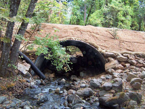 The second phase of the Conner Creek project, the removal of an undersized culvert and placement of a larger, natural stream-bed bottom culvert on Red Hill Road was completed in 2013. In concert with the project on Conner Creek Road, fish can now access 2.5 miles of
of anadromous fishery habitat, including main stem Conner Creek and several tributaries that include designated coho critical habitat. The new crossings reduce maintenance costs associated with storm flows and culvert plugging and/or weir clearing, and eliminate the potential for delivery of approximately 2,189 cubic yards of road fill material into the downstream reaches of Conner Creek and the Trinity River. Read the final report for more information and photos. Check out the photolog for a summary of the project. The second phase of the Conner Creek project, the removal of an undersized culvert and placement of a larger, natural stream-bed bottom culvert on Red Hill Road was completed in 2013. In concert with the project on Conner Creek Road, fish can now access 2.5 miles of
of anadromous fishery habitat, including main stem Conner Creek and several tributaries that include designated coho critical habitat. The new crossings reduce maintenance costs associated with storm flows and culvert plugging and/or weir clearing, and eliminate the potential for delivery of approximately 2,189 cubic yards of road fill material into the downstream reaches of Conner Creek and the Trinity River. Read the final report for more information and photos. Check out the photolog for a summary of the project.
1/23/14: Conner Creek Project Earns National Recognition:
The Conner Creek Fish Passage Improvement Project received Honorable Mention as a "Distinguished Project in Fisheries Engineering and Ecohydrology" by the American Fisheries Society during the 2013 International Conference on Engineering & Ecohydrology for Fish Passage in Corvallis, Oregon on June 26, 2013. The AFS recognition was presented to the Forest Service for their support of the project. Click here to read more about this award.
Previously, the National Fish Habitat Partnership selected Conner Creek as a 2012 top ten Waters to Watch in the United States. This award, assembled by the nation’s leading authorities on aquatic conservation, lists rivers, streams and shores that will be healthier habitats for the fish, wildlife and people who call them home. Read more about this recognition at the NFHP website.
12/31/12: CONNER CREEK#1 - Conner Creek Road Migration Barrier Removal Project completed An existing box culvert with a jump at the outlet and high velocity flows was replaced with a bridge to accommodate 100-year flows and fish migration. The upper 41% of the watershed burned in a 2008 fire, increasing risk of sediments. An upstream partial barrier will be removed in 2012.

"Before" view of Conner Creek at Conner Creek Road
The 5C Counties use a variety of techniques to improve fish passage, storm flow, bedload and debris passage at county road crossings. Engineering staff strive to design projects that balance site and right-of-way constraints with traffic, safety, biologic, geologic/hydraulic, costs and other factors. This approach has resulted in more than 25 separate design approaches.

"After" image of same location-new bridge accomodates storm flows and natural creekbed beneath bridge allows for fish passage
See more images of this project on our Trinity County Featured Project gallery page
Read more about this project in the Trinity Journal newspaper:
12/31/12: CHINA GULCH PHASE 2A - China Gulch Road Completed Ten road erosion sites within a 1-mile stretch of China Gulch Road in Trinity County were addressed during 2010. The picture (below, left) shows an upslope, partially-gutted debris slide and culvert inlet before project implementation. Large rock slope protection (RSP) was installed upstream of the stream crossing. A larger culvert was placed at the crossing and a critical dip was installed across the road (below, right). Final grading and rocking are pending.
 
10/31/11: TRINITY RIVER - Dutch Creek Road Sediment Reduction Project – Phase 2 Construction Begins in 2012. Two proposed treatment sites on Dutch Creek are related to fill failures (below, left) and slides (below, right). This project will include upgrading existing culverts and installing additional ones to dewater ditch segments at the base of active slides. Upslope portions of the project area were burned in 2008.
 
10/31/11: Fisheries Monitoring and Project Design - Sidney Gulch A habitat improvement project for Sidney Gulch is in the planning stages. Sidney Gulch, a tributary to Weaver Creek, is identified as a priority watershed for coho recovery under the CA Coho Recovery Strategy because of year-over-year Coho populations. Sidney Gulch is an integral part of the Weaver Creek fish population matrix. There is potential to increase channel and habitat complexity to support larger populations of Coho, steelhead, and other aquatic species as well as increasing the stream’s carrying capacity.
 10/31/11: Sidney Gulch Migration Barrier Removal Project at Weaver Bally Loop Road The existing structure is a circular corrugated metal pipe 7-foot diameter and 60-feet long set at 4.91%. The culvert is undersized for 100-year flows and estimated to overtop during a 20-year storm flow. When first installed, engineers evaluated the stream and determined the system was aggrading. They subsequently determined that the culvert did not have to be embedded, assuming that it would embed itself naturally. This determination proved to be wrong and the outlet of the culvert remains above grade and has downcut significantly. This new project would improve fish passage and reduce sediment/bedload transport at the stream crossing by replacing one undersized culvert structure with a larger box culvert. 10/31/11: Sidney Gulch Migration Barrier Removal Project at Weaver Bally Loop Road The existing structure is a circular corrugated metal pipe 7-foot diameter and 60-feet long set at 4.91%. The culvert is undersized for 100-year flows and estimated to overtop during a 20-year storm flow. When first installed, engineers evaluated the stream and determined the system was aggrading. They subsequently determined that the culvert did not have to be embedded, assuming that it would embed itself naturally. This determination proved to be wrong and the outlet of the culvert remains above grade and has downcut significantly. This new project would improve fish passage and reduce sediment/bedload transport at the stream crossing by replacing one undersized culvert structure with a larger box culvert.
Back to news index.
For more information contact us
The 5C Enews is funded through the Fisheries Restoration Grant Program through the CA Department of Fish and Wildlife
Image of Chinook Fry at top of page courtesy of USFWS & Dan Cox.
| 